5% Discount for 6 bottles or more Free Delivery or all orders over £150
applied at checkout to all individual wines.
Local Walks - Vineyard through Woodchester to Selsley View Point
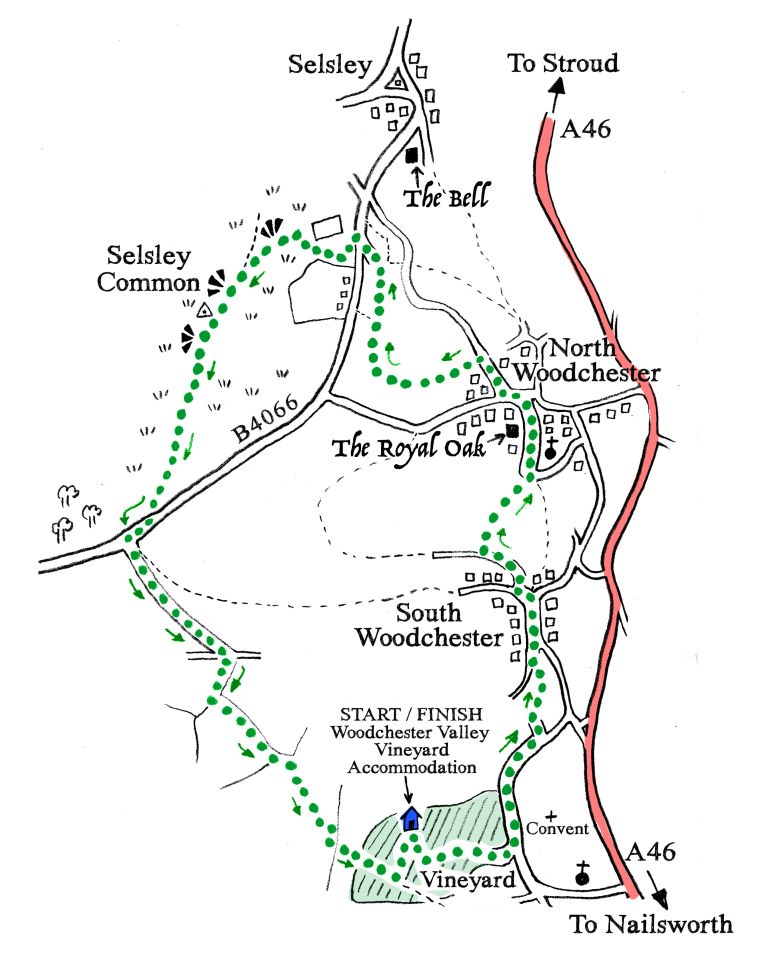
A GOOD WALK AROUND WOODCHESTER UP TO SELSLEY COMMON VIEWPOINT
Distance 7.5 km 2.5 hours
A cracking good walk around Woodchester low to high. Passing through the charming village, then climbing up to the National Trust open grassland and Neolithic long barrow. Excellent views over the wide plain of the Severn estuary, Forest of Dean and Welsh mountains; then back down across farmland and through vineyards with more wonderful valley views.
Drinks and Food- call ahead for hours and bookings
The Royal Oak pub in Woodchester (limited hours)- start of walk
The Bell at Selsley- country pub, great views, half way on walk

START from Woodchester Valley Vineyard Tasting Room
>Walk downhill past the vineyards, at Convent Lane turn LEFT pass the Convent and houses then as road bends downhill come to “Upper Summerwells Cottage” on the right, opposite turn left to gate
>Go through metal kissing gate, into a field, pass pond and redwood trees
>Go through a metal kissing gate across driveway and straight on through another kissing gate
>Enter field (usually has horses in) follow well-worn path up to large tree then diagonally up to left corner of field with step through metal stile. (There is a bench to rest here and enjoy views of the industrial heritage buildings and the Amberley vineyards).
>Walk up a few steps and turn RIGHT on to road, pass houses on both sides and then slightly downhill to meet a road
>Turn LEFT passing old well with water gushing out at spring line, continue ahead through old part of village until reaching a half-timbered house and a crossroads called “CORNERWAYS”
> At “CORNERWAYS” turn LEFT up very steep lane then shortly
>Turn RIGHT on to Laggar Lane. After last house and before a large wooden garage building
>Turn RIGHT down steps follow pathway down past garden
> Over stile into field and downhill through the delightful landscaped parkland of Woodchester House with many fine specimen trees and a very grand old oak tree on the path down
>Cross over the stream on wooden footbridge, path leads up towards the church, through trees passing through a metal kissing gate.
>Emerge left onto tarmac road with Church on your right, continue on through village with houses on both sides and pass THE ROYAL OAK pub on your left
> At road turn LEFT uphill for a little way until you reach Selsley Lodge on right
>Turn RIGHT along narrow road, at end of wall on right, shortly after farm outbuilding on left
>Turn LEFT through stile and keeping to the left edge of field climb up towards woods. Stop for a while and turn around to enjoy wonderful views out across the valley below.
>Cross stile to enter woods, follow path as it bears towards the right and emerge into steep orchard field below a house
>Cross the field slightly uphill and enter small copse, cross stile and then cross another stile.
>Cross the next field and then climb up towards electricity pole between houses.
> Cross stile to the left of pole and emerge onto Selsley Common a National Trust limestone grassland (Note: a short detour right 400m downhill on the road brings you to The Bell at Selsley, booking generally required)
>Follow track ahead up towards road, cross road and then follow track up as it zig-zags steeply left then right with stand of conifers on the right, up to the top where there is a welcome bench to rest with expansive views of the valley you have just climbed out of
>Keep on going up as the panorama opens out in front of you, there are lots of hollows from the old Cotswold stone quarries keep to the right of these, bearing gradually left as you climb up to reach the top
>At the top there are hollows from quarries on your right, (some have modern rock art inside!) great views. Head across common heading in direction of long stone farmhouse in the distance, at the end of the quarry hollows bend right to make a small side trip out for viewpoint and mound
> Pass a Millennium Stone viewpoint marker and make for the well-defined mound of “The Toots” beside it, a Neolithic long barrow circa 2500 BC. (The name Toots is used at other ancient beacon sites and so probably means an elevated look-out). You are now walking through a limestone grassland landscape with rare flora and fauna. You may see cattle grazing freely as commoners have the right to the rich summer grazing on these hills. Climb up the Toots and rest here awhile to enjoy fine views across the River Severn and far into Wales. This last escarpment ridge of the Cotswolds is dotted with Neolithic barrows, Bronze and Iron Age Hill forts. It is easy to see why they were so important strategically and economically as vital prehistoric trade routes.
> Head across common towards woods, past pylon and then head left for long farmhouse building
>Cross road to signpost for “Bown Hill Farm” and pass through gate to the left of a cattle grid
>Walk ahead up tree lined driveway to a junction
>Cross over another driveway and turn right
>Follow path with wall on left until you reach a metal gate with stile on left
>Cross stile into field, follow path down through field with winding stone wall on left, good views
>Cross stile into second field and follow pathway generally down along fence line in direction of telegraph poles
>As path bears to the right after passing under power cables look for tall wooden kissing gate on the left and enter field
>Cross middle of field following power lines to gap in hedge (this is the most recent planting of Pinot Noir vines)
>Go through gap in hedge and then bear right on wide path with wood on the right and vines on the left
>At corner broad grassy path bends left under power line to follow hedge and then wood on right, with large field of Bacchus vines on your left
>On reaching the tarmac road and cattle guard:
Turn LEFT up stone road for the Vineyard Barns.
Turn LEFT up tarmac road for The Retreat.
Turn RIGHT down stone road for Woodchester Valley House.
Enjoy a well-deserved glass of wine!

